London moves fast. One minute you’re standing in Heathrow Airport with luggage in hand, and the next you’re expected to navigate one of the busiest transport systems in the world like a local. That’s where the Elizabeth Line map becomes more than just a transit diagram — it becomes your survival guide.
Since its launch, the Elizabeth Line has transformed travel across London. Faster connections, modern stations, smoother interchanges, and reduced travel times have changed the way commuters, tourists, and business travelers move around the capital. In 2026, the network is more essential than ever.
Whether you’re planning your first trip, commuting daily, or simply trying to understand the London rail network better, this complete guide covers everything you need to know about the Elizabeth Line map, including routes, zones, stations, fares, travel hacks, accessibility, and future expansions.
What Is the Elizabeth Line?
The Elizabeth Line is a high-frequency railway service that runs east to west across London and beyond. Named after Queen Elizabeth II, the route connects major destinations including Heathrow Airport, Canary Wharf, Paddington, Liverpool Street, Abbey Wood, and Reading.
It operates as part of the Transport for London system but feels very different from the traditional Underground experience. The trains are larger, stations are newer, and journeys are significantly quicker.
The Elizabeth Line map helps passengers understand how the route connects key districts, suburban towns, airports, and central London transport hubs.
Why the Elizabeth Line Matters in 2026
London’s population continues to grow, and transport demand keeps rising. The Elizabeth Line has reduced congestion on older Tube lines while offering faster alternatives for travelers.
Here’s why the line has become so important:
- Faster east-west travel
- Direct airport connections
- Reduced travel time across Central London
- Step-free accessibility
- Air-conditioned trains
- Improved commuter experience
- Better connectivity to National Rail services
- Easier interchange with London Underground lines
For many Londoners, checking the Elizabeth Line map before traveling is now as common as checking the weather.
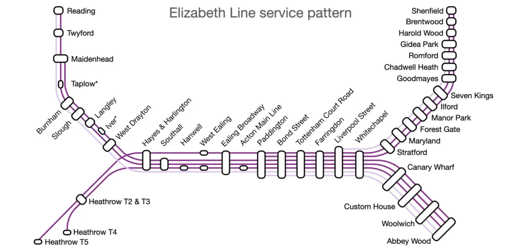
Understanding the Elizabeth Line Map
At first glance, the Elizabeth Line map looks simple. However, there are several branches, central tunnels, interchange stations, and fare zones worth understanding.
Main Route Overview
The line runs through three primary sections:
| Section | Key Areas Covered |
|---|---|
| Western Branch | Reading, Heathrow, Slough, Paddington |
| Central Section | Bond Street, Tottenham Court Road, Farringdon |
| Eastern Branch | Canary Wharf, Woolwich, Abbey Wood, Shenfield |
The central section is where the fastest underground-style service operates. Trains here arrive frequently, making commuting extremely efficient.
Major Stations on the Elizabeth Line
Some stations stand out because of their importance for business, tourism, and interchange connections.
Paddington
One of London’s busiest rail hubs. Excellent for airport transfers and National Rail services.
Bond Street
Perfect for shopping and West End access. Luxury retail lovers practically live here during weekends.
Tottenham Court Road
A hotspot for entertainment, dining, and connections to the Central and Northern lines.
Farringdon
Arguably one of the most useful stations on the Elizabeth Line map because it links with Thameslink and the London Underground.
Canary Wharf
The financial heart of London. The station itself feels more like an airport terminal than a Tube station.
Abbey Wood
An increasingly popular residential area thanks to faster travel into Central London.
Elizabeth Line Zones Explained
London transport zones can confuse even experienced travelers. The Elizabeth Line crosses multiple fare zones, so understanding them can save money.
Zone Breakdown
| Zone | Areas Included |
|---|---|
| Zone 1 | Central London stations |
| Zone 2-3 | Inner London districts |
| Zone 4-6 | Outer London suburbs |
| Beyond Zone 6 | Reading and Heathrow connections |
Travel costs vary depending on:
- Time of day
- Distance traveled
- Payment method
- Peak or off-peak hours
Using Oyster cards or contactless payments usually offers the cheapest fares.
Heathrow Airport and the Elizabeth Line
One reason the Elizabeth Line map became instantly popular was its airport connection.
Travelers can now move from Heathrow Airport to Central London without expensive taxi rides or confusing transfers.
Heathrow Travel Benefits
- Direct trains to Central London
- Lower fares than Heathrow Express
- Spacious luggage areas
- Air-conditioned carriages
- Frequent departures
For budget-conscious travelers, the Elizabeth Line is often the smartest option.
Reading the Elizabeth Line Map Efficiently
A lot of visitors make the mistake of treating the line like a normal Underground route. It isn’t exactly the same.
Here’s how to read the map efficiently.
Follow Branch Endings Carefully
Not every train goes to every destination.
For example:
- Some western services terminate at Heathrow
- Others continue to Reading
- Eastern trains may end at Abbey Wood or Shenfield
Always check:
- Platform screens
- Train destination boards
- Digital announcements
Use Interchange Symbols
The Elizabeth Line map highlights stations where you can switch to:
- London Underground
- National Rail
- Thameslink
- DLR
- Overground services
These interchanges save huge amounts of travel time.
Elizabeth Line vs London Underground
People often compare the Elizabeth Line with the Tube. While both are part of London transport, the travel experience is noticeably different.
| Feature | Elizabeth Line | London Underground |
|---|---|---|
| Train Size | Larger | Smaller |
| Air Conditioning | Yes | Limited |
| Accessibility | Excellent | Mixed |
| Wi-Fi & Mobile Signal | Better coverage | Improving |
| Speed | Faster | Moderate |
| Station Design | Modern | Traditional |
The Elizabeth Line feels cleaner, quieter, and more spacious overall.
Best Tourist Destinations on the Elizabeth Line
One underrated advantage of the Elizabeth Line map is how easily it connects major attractions.
West End
Use:
- Bond Street
- Tottenham Court Road
Ideal for:
- Shopping
- Musicals
- Restaurants
- Nightlife
Canary Wharf
Perfect for:
- Riverside walks
- Fine dining
- Business meetings
- Modern architecture
Paddington Area
Close to:
- Hyde Park
- Little Venice
- Lancaster Gate
Liverpool Street
Excellent access to:
- Spitalfields Market
- Shoreditch
- Brick Lane
Elizabeth Line Travel Tips for 2026
After using the line regularly, frequent passengers tend to develop small habits that make journeys smoother.
Avoid Peak Hours
Peak times can still become crowded:
- 7:00 AM – 9:30 AM
- 4:30 PM – 7:00 PM
Midday travel is far more comfortable.
Stand in the Correct Carriage
Some stations have exits closer to specific carriages. Regular commuters save several minutes simply by standing strategically.
Use Contactless Payment
It’s quicker than buying paper tickets and often cheaper.
Download Offline Maps
Mobile signal has improved dramatically, but offline maps remain useful during disruptions.
Accessibility on the Elizabeth Line
One of the biggest achievements of the network is accessibility.
Many older Tube stations still struggle with:
- Narrow platforms
- Stair-only access
- Large platform gaps
The Elizabeth Line changed that.
Accessibility Features
- Step-free access
- Elevators
- Wide gates
- Visual announcements
- Audio announcements
- Wheelchair spaces
- Level boarding
This makes travel easier for:
- Parents with strollers
- Elderly passengers
- Travelers with luggage
- Disabled commuters
Elizabeth Line Fares and Costs
Prices depend on:
- Zones traveled
- Payment method
- Time of travel
Typical Fare Examples
| Journey | Approximate Cost |
|---|---|
| Heathrow to Paddington | Moderate |
| Canary Wharf to Bond Street | Affordable |
| Reading to Central London | Higher fare |
Using contactless bank cards generally caps daily spending automatically.
That means once you hit a daily limit, additional travel becomes free for the rest of the day.
How Safe Is the Elizabeth Line?
Safety is one reason many passengers prefer the service.
Stations include:
- CCTV surveillance
- Modern lighting
- Staff presence
- Emergency help points
Late-night travel feels safer compared to some older Underground routes.
Of course, like any major city transport network, staying aware of your belongings remains important.
Future Expansion Plans
Transport planners continue discussing future improvements to the network.
Possible developments include:
- Increased train frequency
- Additional services to outer suburbs
- Better interchange systems
- Expanded digital ticketing
- Smarter passenger information systems
As London grows, the Elizabeth Line map will likely evolve too.
Common Mistakes Travelers Make
Even experienced tourists occasionally get confused.
Assuming Every Train Stops Everywhere
This is probably the most common mistake.
Always confirm:
- Final destination
- Stopping pattern
- Branch route
Confusing Elizabeth Line With Underground Lines
Although integrated into London transport, the service operates differently in several ways.
Ignoring Fare Zones
Traveling beyond central zones can increase costs quickly.
Best Apps for Elizabeth Line Navigation
Technology makes commuting easier than ever.
Popular travel apps include:
- TfL Go
- Citymapper
- Google Maps
- Apple Maps
These apps provide:
- Live departure times
- Platform updates
- Service disruptions
- Alternative routes
Still, having a basic understanding of the Elizabeth Line map remains valuable when mobile data fails.
Elizabeth Line During Major Events
London becomes incredibly busy during:
- Football matches
- Concerts
- Christmas shopping season
- New Year celebrations
The Elizabeth Line helps reduce pressure on older transport lines during these events.
However, stations like:
- Bond Street
- Tottenham Court Road
- Liverpool Street
can still become extremely crowded.
Traveling slightly earlier or later often makes a massive difference.
Is the Elizabeth Line Worth Using?
Absolutely.
For many passengers, it has completely changed how they travel across London.
The biggest advantages include:
- Faster journeys
- Comfortable trains
- Easier airport transfers
- Better accessibility
- Reduced commuting stress
Even longtime London residents often admit the line exceeded expectations.
Quick Guide to Key Elizabeth Line Stations
| Station | Best For |
|---|---|
| Paddington | Heathrow connections |
| Bond Street | Shopping |
| Farringdon | Interchanges |
| Canary Wharf | Business district |
| Liverpool Street | East London access |
| Abbey Wood | Residential commuting |
Frequently Asked Questions
Is the Elizabeth Line open 24 hours?
No, the service does not currently run 24/7. However, operating hours are extensive.
Can I use Oyster cards?
Yes. Oyster cards and contactless bank cards are accepted.
Is the Elizabeth Line faster than the Tube?
In many cases, yes. Especially for cross-city journeys.
Does the Elizabeth Line go to Heathrow?
Yes. It provides direct airport access.
Are Elizabeth Line trains air-conditioned?
Yes, which is a huge advantage during summer travel.
Final Thoughts on the Elizabeth Line Map
The Elizabeth Line map is more than a transit tool. It represents a major shift in how London moves.
For commuters, it saves time. For tourists, it simplifies exploration. For businesses, it improves connectivity across the city. And for travelers arriving at Heathrow, it offers one of the easiest ways to enter Central London.
Understanding the Elizabeth Line map before your journey can save stress, money, and valuable time. Once you learn the routes, interchanges, and branch patterns, navigating London becomes dramatically easier.