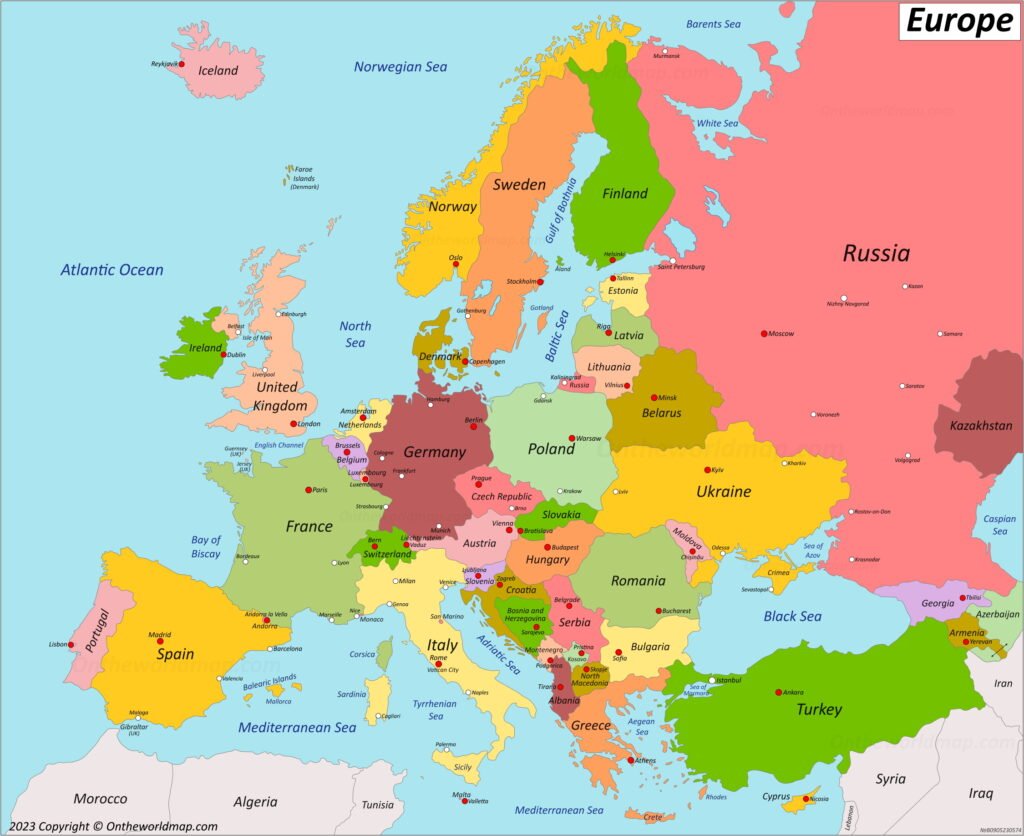
Europe may be the world’s second-smallest continent by land area, but few places pack in as much history, cultural diversity, and political complexity. One glance at a map of Europe reveals a fascinating patchwork of countries, languages, mountain ranges, coastlines, and borders that have shifted dramatically over centuries.
From the icy landscapes of Scandinavia to the sun-drenched Mediterranean shores, Europe’s geography tells the story of empires, migrations, wars, trade routes, and modern cooperation. Whether you’re a student, traveler, teacher, or simply curious about world geography, understanding the map of Europe helps make sense of the continent’s unique identity.
In this guide, we’ll break down Europe’s countries, explain how its borders developed, and explore the regions that shape this remarkable continent today.
Understanding the Map of Europe
At first glance, the map of Europe can seem overwhelming. Despite its relatively small size, Europe contains nearly 50 sovereign states, multiple language families, and a mix of political and cultural regions.
Europe covers approximately 10.18 million square kilometers and stretches from the Atlantic Ocean in the west to the Ural Mountains in the east. It shares a land border with Asia, making Europe and Asia part of the larger Eurasian landmass.
What Defines Europe’s Boundaries?
Unlike continents separated by oceans, Europe’s eastern border is based largely on historical and cultural agreements.
The commonly accepted boundaries include:
- The Arctic Ocean to the north
- The Atlantic Ocean to the west
- The Mediterranean Sea to the south
- The Ural Mountains and Ural River to the east
- The Caucasus Mountains in the southeast
- The Black Sea and Bosporus Strait separating parts of Europe and Asia
These natural landmarks help define what appears on a modern map of Europe.
How Many Countries Are in Europe?
Depending on political recognition and geographic interpretation, Europe contains between 44 and 50 countries.
Most educational maps recognize 44 sovereign nations entirely within Europe, while others include transcontinental countries.
Countries Entirely in Europe
Examples include:
- France
- Germany
- Italy
- Spain
- Portugal
- Poland
- Sweden
- Norway
- Finland
- Greece
- Austria
- Hungary
- Belgium
- Netherlands
- Switzerland
Transcontinental Countries
Some countries appear on both the European and Asian sides of the map of Europe.
These include:
- Russia
- Turkey
- Kazakhstan
- Azerbaijan
- Georgia
Their classification often depends on geographic, political, and cultural perspectives.
Major Regions of Europe
Understanding regional divisions makes the map of Europe much easier to read.
Northern Europe
Northern Europe includes:
- Denmark
- Norway
- Sweden
- Finland
- Iceland
This region is known for:
- Nordic culture
- Fjords and glaciers
- High living standards
- Renewable energy initiatives
- Arctic landscapes
Western Europe
Western Europe features some of the world’s largest economies.
Countries commonly included are:
- France
- Germany
- Belgium
- Netherlands
- Luxembourg
- Austria
- Switzerland
Key characteristics include:
- Dense transportation networks
- Major financial centers
- Historic cities
- Strong industrial economies
Southern Europe
Southern Europe surrounds the Mediterranean basin.
Notable countries include:
- Italy
- Spain
- Portugal
- Greece
- Croatia
- Malta
The region is famous for:
- Ancient civilizations
- Mediterranean climate
- Coastal tourism
- Historic architecture
- Culinary traditions
Eastern Europe
Eastern Europe is diverse in both geography and culture.
Countries often classified in this region include:
- Poland
- Ukraine
- Romania
- Bulgaria
- Belarus
- Moldova
The region contains:
- Vast plains
- Orthodox Christian heritage
- Emerging economies
- Rich folk traditions
Central Europe
Central Europe sits between eastern and western influences.
It generally includes:
- Czech Republic
- Slovakia
- Hungary
- Slovenia
These countries serve as cultural crossroads and play important roles in European trade and transportation.
The European Union and the Map of Europe
One common misconception is that Europe and the European Union are the same thing.
They are not.
The European Union (EU) is a political and economic partnership of member states, while Europe is a geographic continent.
Not every country on the map of Europe belongs to the EU.
Countries in Europe but Outside the EU
Examples include:
- Norway
- Switzerland
- Serbia
- Albania
- Ukraine
- United Kingdom
Likewise, some EU territories exist outside continental Europe.
Understanding this distinction helps avoid confusion when reading political maps.
The Schengen Area Explained
Another important feature of the map of Europe is the Schengen Area.
This agreement allows passport-free travel between participating countries.
Travelers can often cross borders without routine checks, creating one of the world’s largest free-movement zones.
However, the Schengen Area differs from both the European Union and the eurozone.
For example:
- Switzerland is in Schengen but not the EU.
- Ireland is in the EU but not fully part of Schengen.
Europe’s Physical Geography
Political boundaries tell only part of the story. Physical features are equally important on any map of Europe.
Major Mountain Ranges
Europe’s most significant mountain systems include:
- The Alps
- The Pyrenees
- The Carpathians
- The Apennines
- The Scandinavian Mountains
- The Caucasus
These ranges influence climate, transportation, and settlement patterns.
Major Rivers
Several major rivers connect countries and support trade.
Key waterways include:
- Danube River
- Rhine River
- Volga River
- Seine River
- Thames River
- Elbe River
The Danube flows through multiple countries, making it one of Europe’s most international rivers.
Peninsulas of Europe
A detailed map of Europe highlights several important peninsulas:
- Iberian Peninsula
- Italian Peninsula
- Balkan Peninsula
- Scandinavian Peninsula
- Jutland Peninsula
These landforms have shaped migration, commerce, and military history.
Seas and Coastlines
Europe has one of the world’s most complex coastlines.
Important bodies of water include:
- Mediterranean Sea
- Baltic Sea
- North Sea
- Black Sea
- Adriatic Sea
- Aegean Sea
- Norwegian Sea
- Irish Sea
These waters support trade routes, tourism, fishing industries, and maritime transportation.
How European Borders Have Changed Over Time
Today’s map of Europe is the result of centuries of change.
Empires rose and fell, kingdoms merged, and new nations emerged.
Key historical events that reshaped European borders include:
- The fall of the Roman Empire
- The Ottoman expansion
- The Napoleonic Wars
- World War I
- World War II
- The breakup of the Soviet Union
- The dissolution of Yugoslavia
As recently as the 1990s, several new countries appeared on the European map.
This constant evolution explains why Europe’s borders often seem more complex than those of other continents.
The Largest and Smallest Countries in Europe
Largest Countries by Area
| Country | Approximate Area |
|---|---|
| Russia (European portion included) | 17.1 million km² total |
| Ukraine | 603,000 km² |
| France | 551,695 km² |
| Spain | 505,990 km² |
| Sweden | 450,295 km² |
Smallest Countries
| Country | Approximate Area |
| Vatican City | 0.49 km² |
| Monaco | 2.02 km² |
| San Marino | 61 km² |
| Liechtenstein | 160 km² |
| Malta | 316 km² |
These microstates occupy tiny spaces on the map of Europe, yet each has its own government, culture, and history.
Capitals That Shape Europe
Many European capitals serve as cultural and political hubs.
Notable examples include:
- Paris, France
- Berlin, Germany
- Rome, Italy
- Madrid, Spain
- Lisbon, Portugal
- Warsaw, Poland
- Athens, Greece
- Vienna, Austria
- Prague, Czech Republic
- Stockholm, Sweden
These cities influence everything from diplomacy and finance to art and tourism.
Why Learning the Map of Europe Matters
Understanding the map of Europe goes beyond memorizing countries and capitals.
It helps you:
- Follow global news more easily
- Understand international politics
- Plan travel routes efficiently
- Learn world history in context
- Appreciate cultural diversity
- Recognize economic partnerships
- Understand migration patterns
Whether you’re watching international sporting events, reading about global affairs, or planning a European vacation, geographic knowledge adds valuable context.
Common Challenges When Reading a Map of Europe
Many people struggle with European geography because of:
- Similar country names
- Frequent border changes throughout history
- Different regional definitions
- Transcontinental nations
- Small countries clustered together
A good approach is to study Europe by region rather than trying to memorize the entire continent at once.
Start with major landmarks, then learn countries, capitals, and neighboring states.
Over time, the map of Europe becomes far easier to understand.
Quick Facts About Europe
- Europe is home to more than 740 million people.
- It contains dozens of official languages.
- Russia is Europe’s largest country by area.
- Vatican City is the smallest independent state.
- The Danube flows through more countries than any other river in Europe.
- The Alps span eight countries.
- Europe has some of the world’s busiest international borders.
Conclusion
The map of Europe is far more than a collection of lines and labels. It reflects thousands of years of history, cultural exchange, political change, and geographic diversity.
From the rugged mountains of the Alps to the coastal cities of the Mediterranean, every border tells a story. Understanding Europe’s countries, regions, waterways, and political organizations gives you a clearer picture of how the continent functions today.
The next time you look at a map of Europe, don’t just see countries—see the connections between people, landscapes, and history that continue to shape one of the world’s most influential regions.